


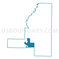
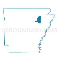
Ingleside Voting District, Jackson County, Arkansas
About
Outline

Summary
| Unique Area Identifier | 526784 |
| Name | Ingleside Voting District |
| County | Jackson County |
| State | Arkansas |
| Area (square miles) | 22.99 |
| Land Area (square miles) | 21.87 |
| Water Area (square miles) | 1.12 |
| % of Land Area | 95.13 |
| % of Water Area | 4.87 |
| Latitude of the Internal Point | 35.47922500 |
| Longtitude of the Internal Point | -91.30512370 |
Maps

Graphs
Select a template below for downloading or customizing gragh for Ingleside Voting District, Jackson County, Arkansas


Neighbors
Neighoring Voting District (by Name) Neighboring Voting District on the Map
- Auvergne Voting District, Jackson County, AR
- Horseshoe Voting District, Jackson County, AR
- Island Voting District, Jackson County, AR
- Macks Voting District, Jackson County, AR
- New Glaise Voting District, Jackson County, AR
- North Rural Augusta Precinct 4, Woodruff County, AR
- Olyphant Voting District, Jackson County, AR
- Shoffner Voting District, Jackson County, AR
- Weldon Voting District, Jackson County, AR
Top 10 Neighboring County Subdivision (by Population) Neighboring County Subdivision on the Map
- Union township, Jackson County, AR (7,518)
- Glaize township, Jackson County, AR (966)
- Breckenridge township, Jackson County, AR (478)
- Bryan township, Jackson County, AR (106)
- White River township, Woodruff County, AR (86)
- Bateman township, Jackson County, AR (52)
Top 10 Neighboring Unified School District (by Population) Neighboring Unified School District on the Map
Top 10 Neighboring State Legislative District Lower Chamber (by Population) Neighboring State Legislative District Lower Chamber on the Map
Top 10 Neighboring State Legislative District Upper Chamber (by Population) Neighboring State Legislative District Upper Chamber on the Map
Top 10 Neighboring 111th Congressional District (by Population) Neighboring 111th Congressional District on the Map
Top 10 Neighboring Census Tract (by Population) Neighboring Census Tract on the Map
- Census Tract 4804, Jackson County, AR (4,669)
- Census Tract 4802, Jackson County, AR (3,714)
- Census Tract 4902, Woodruff County, AR (2,774)
- Census Tract 4805, Jackson County, AR (1,928)